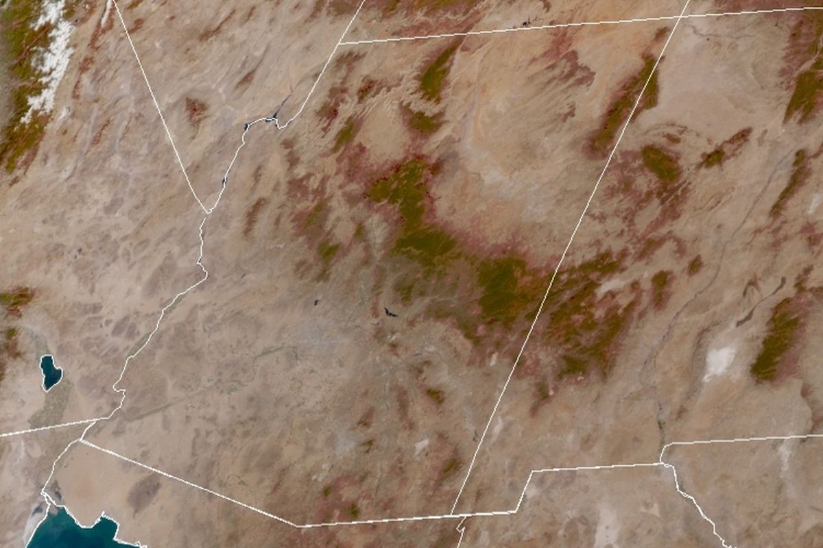
The skies are a little cloudy today, although over the weekend and a couple of days before that, there were no visible clouds over Arizona and much of the Southwest. I captured the GOES East image above last Thursday and cropped/resized it for this post.
Observing the cloud free image reveals some interesting things that can be seen from the satellite. You may have to click on the image to enlarge it to be able to see what I’m going to mention below.
First, in the upper left corner of the image, snow on the Sierra Nevada mountains is visible next to the Owens Valley in California. To the South, you can see the Salton Sea located in Riverside and Imperial Counties. Southeast of the Salton Sea across the Arizona/Mexico border in Sonora is a darker area which is Pinacate Peaks volcanic area just north of the Gulf of California, the north shores of which is at the bottom of the image.
Now, going north along the CA/AZ border (the Colorado River), you eventually come to Lake Mohave on the NV/AZ border. Then, continue up to Lake Mead where the river turns to the east along the border. Lake Mead shows as a couple of blue blobs but it is actually one body of water partially obscured by the overlaid graphic representing the border.
The dark area about one third of the way across Arizona’s north border is the Kaibab National Forest which extends southward to the North Rim of the Grand Canyon which can be seen between Kaibab Plateau and the forests of the South Rim below the Canyon.
The dark areas extending south and east below the Grand Canyon are the forested areas of Arizona. The north boundaries of these forests form a semi circular feature which is the Mogollon Rim (say “muggy-yon”). This forms the boundary between the forests and colorful high desert areas of Arizona. We can personally tell you that the scenery up on the Rim is extremely nice.
Moving over into New Mexico, we have a couple of notable features. The white spot in lower central NM is White Sands National Park. Also visible is the Rio Grande River which can be seen flowing from the west Texas town of El Paso up through Albuquerque and although not seen in this image, into southern Colorado.
I like it when the clouds part and I can see all these features and more.
ISP Software Upgrade Progress: I have started migrating our personal family blog to the new software. Progress is impeded by daily life events – dogs – family – home chores – blogging – and the like. I should have a report about the Cap’n Bob site soon.
 Well, we’re updating the theme again. This time, I found a “modern” WP theme (“Blogstream“) that mostly meets my personal desires in what a theme should do and how adaptable it might be for my purposes. At the moment, it is still pretty much “stock” in that I am only using native widgets to facilitate the sidebar information. The colors and flag banner in the new theme are reminiscent of the old Stars and Stripes theme (image above right). There is a full-size image of the old theme here


