Camping Day Three – Torrey, UT – Plus 9/11 Thoughts

Wonderland Campground

Day three finds us camping in Torrey, Utah which is about ten miles west of the entrance to Capitol Reef National Park. Today, like the first days of our excursion, we passed some incredible Western American scenery. We started near Lake Powell and climbed through southern and central Utah reaching a summit of almost 8400 feet above mean sea level.

Tomorrow, we will break camp, spend some time at the Capitol Reef National Park (neither of us have been here before) and then proceed northbound towards the Salt Lake City area where we have more camping planned. It is certain to be another spectacular scenery day for us.

Thoughts on the fifteenth anniversary of the 9/11 attacks

I was going to post something to commemorate the 9/11 attacks as usual, but since we are on the road, I did not have much time to come up with a suitable tribute. However, our long-time internet pal in Hawaii, Kini, says it best. His post tells it like it is when it comes to who are really the enemies of freedom. (Besides the Democrats, that is.)

Camping Day Two – Page, AZ

Jacked Up

Day two finds us in Page, Arizona after spending the day driving from Williams up through Grand Canyon National Park and then on up through the Navajo Reservation to where we are camped tonight. The drive was through some of the most scenic and colorful places on the planet and not all of it in Grand Canyon. Northbound along US 89 from Cameron is also quite spectacular.

The Page campground is a little funky. Our campsite is a pull-through towards the uphill side of the RV park. We are on a bit of a slope and when we did the automatic leveling of the RV, the front wheels are completely off the ground; you can see that in the image above.

Tomorrow, we will be in Utah after a short drive from our campground. Our destination is a nice little campground near Capitol Reef National park. We expect to see a lot more beautiful scenery when we head up that direction.

Camping Day One – Williams, AZ

Williams, AZ

Our first day out was pretty entertaining except for some congestion on I-40 due to road construction, but enough about that. Elsewhere, traffic was pretty good considering we were traveling on a getaway Friday along the main route between Phoenix and Las Vegas.

We made our first stop at Wickieup, AZ, after going through some pretty scenic areas like rock formations, a Joshua Tree forest and just beautiful places in general. We also stopped in touristy Seligman, AZ, where Damsel did some souvenir shopping at the Roadkill Cafe. We arrived here in Williams this afternoon, checked in and set up camp in the quaint Canyon Motel and RV Park.

Tomorrow, we’re going to top off the fuel tank here in town before heading up US 64 towards Grand Canyon. We checked fuel prices at our next stop and thought it best to tank up here even though we’re still half full. We can refuel when we get up into Utah where prices get lower again.

We will have more tomorrow from the next stop.

NWS Weather Radar Limitation

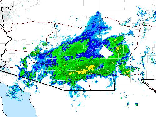
Blank AreaThis is a screenshot segment of the National Radar Mosaic showing the remnant of Hurricane Newton over Arizona and New Mexico. I thought it strange that there should be a blank, almost rectangular feature in the radar echoes until I realized what it was. A quick look at the surrounding radar installations revealed that the blank spot, which is located almost entirely within the southwest corner of Catron County, New Mexico, is beyond the range of the four adjacent radar installations from which the composite is made. That area is unseen by the radars at Tuscon, El Paso, Albuquerque and Flagstaff.
The population of the entire County affected is a little over 3600 total, so there aren’t that many people affected by the lack of radar coverage, although Reserve, NM, the county seat appears to be in the blank area. I just thought the blank spot was amusing enough to post about it here.

More Tropical Weather Headed for Arizona

Hurricane Newton Track Forecast Tropical Clouds over Wickenburg

We’re in for some effects resulting from Hurricane Newton, currently crossing the Sea of Cortez in Mexico heading northward. In the images above, left to right, the visible satellite image showing clouds over the area, the probable path and intensity of the storm and a photo of some of the upper level clouds and moisture over us. Click on any image to enlarge.

Southeastern Arizona and Southwestern New Mexico are expected to endure some tropical weather over the next couple of days with isolated rain showers and flash flooding. Up here, we can already see the effects of the storm. Today started out crystal clear then after about 3 PM, the clouds associated with Hurricane Newton started to cover the area.

The following is an excerpt from a NOAA prognosis:

Newton continues to be a large tropical cyclone, and hazards extend well away from the center. These hazards will affect a large portion of Baja California Sur, northwestern Mexico, and southeastern Arizona during the next day or so. Moisture associated with the remnants of Newton are likely to cause heavy rains and localized flash flooding over parts of Arizona and New Mexico Wednesday and Thursday.

We’re not expecting high probabilities of storms (only 10 to 20 percent) but we’re well-stocked and will be ready for it if it comes.

A Black Butterfly Browsing the Red Birds

Browsing the Red Birds

Late this morning, I noticed a butterfly in the courtyard among the Red Bird of Paradise flowers. I quickly got my Canon EOS camera and went out front to see if I could get some shots of the butterfly before it flew away.

The butterfly flitted here and there for a while after I got out front, but it finally settled on one of the flowers long enough for me to capture it and its pollen laden wings in this image. Click on the image to enlarge. I also got some other good images here and here.

CB&D Website Changes Underway

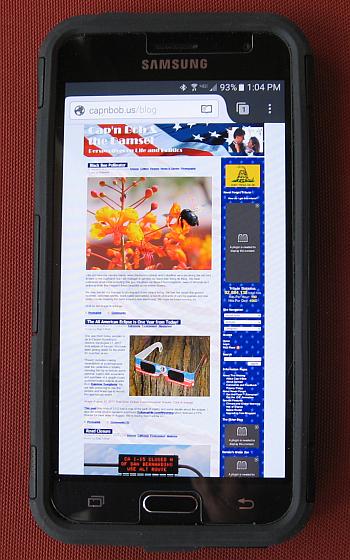
Smartphone on WeblogNow that I have upgraded to a smartphone, it has become obvious to me that our websites are definitely not handheld mobile friendly. Shortcomings we have noted include small text size and flaky mobile application plug-in support for our various Flash® animations.

I have already taken the first step toward compatibility by replacing our animated banner with a static image. Next steps will be (as we get to it) replacing the little animated doodads with static images, or removing those that do not have a static equivalent, including the Never Forget animated tribute.

It troubles me to do away with this animation which has been a memorial to the 9/11 terrorist attacks on this site for over ten years, but the traffic count on the hit indicator at the right under the animation has been diminishing steadily. When the hit counter passed sixty million in February of 2010, the hits per hour were nearly 1300; when the counter passed ninety million, the hits per hour had diminished to 529. The current hits per hour is under 200, so it is time to phase the tribute out.

Image: How this site looks on my new Samsung Galaxy mobile

I will clean up the incompatible items on all of our sites over a period of time (read when I get around to it) and begin looking at ways to detect device type and to issue a compatible format. This latter effort may take a while since I use a very old version of WordPress and I will have to customize things in the old code rather than upgrading to a new version incompatible with the current database structure.

It might just be too much work to convert the whole site, so I might incorporate a mobile only splash page that directs the mobile user to switch to a larger tablet or a full-size computer screen. I have only begun to research the changeover, so stay tuned.