Environment

First Day of Winter

winter.jpg
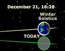
Well, the first day of winter officially began at 0928 Arizona time this morning. The image snippet I captured from Archaeoastronomy.com shows the time of the solstice in UTC. Arizona time is seven hours earlier.

I know that those in chronically colder places will regard this as whining, but it’s very cold here in the desert today. When I was out with the dogs this morning, it was 43° and wind gusts to 25 knots. I was wearing sweats and, believe me, the wind went right through the thin flannel. Neither I, nor the dogs, could wait to get back into the nice warm 68° inside temperature.

Although the temperature never exceeded 52° here today, the forecast for Christmas weekend is for less wind and warmer with highs back up in the 70s. Today, we’re looking ahead to that.

On a different winter topic, The Patriot Post featured this Rick McKee cartoon with reference to the recently passed GOP Tax Reform:

grinch-dems.jpg

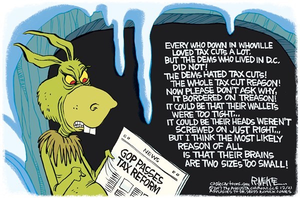
The fine print disclaimer includes apologies to Dr. Seuss. 😆

Persistent Second Spring Weather

Bottle Brush Devil’s Tongue Cactus Flower

The butterflies, bees and hummingbirds are still going strong even though we’re in the middle of December. Our daytime temperatures have been in the mid to upper seventies and the nights, although cool, have been mild in the upper forties to lower fifties.

I took both of these photos today. The flower on the left is on a bottle brush shrub in the courtyard and the flower on the right is on a Devil’s Tongue barrel cactus in the rock and cactus xeriscape garden across the driveway to the west.

The official first day of winter will be in a week or so, but we are hoping that our spring-like days will continue for a while. Click on either image to enlarge.

Great American Solar Eclipse – Totality

Totality Sequence

The eclipse last month as seen from our vantage point in Casper, WY: early, mid and late totality. The moon was moving from the upper right to the lower left in this perspective. You will note the vignette of longer wavelength light along the lower left of the first image and along the upper right of the third image. The mid eclipse image did not have much direct sunlight refracting around the limb of the moon.

When you click on the image to enlarge it, you will need to scroll both horizontally and vertically since I left Damsel’s originals at full resolution, each being a bit over 1300 pixels square. You can view the early, mid and late totality by clicking the three previous links.

The images were taken at approximately 11:54, 11:55 and 11:56 AM, on August 21, 2017, Wyoming time. Totality lasted 2 minutes and 26 seconds from our vantage point in Casper.

The next American total eclipse which will take place on April 08, 2024 will have a totality lasting over four minutes from where we currently are planning to watch near Kerrville, Texas. The duration is longer, I guess, because the Earth will be closer to aphelion and the Moon will be closer to perigee than was the case two weeks ago.

Camping – Sisseton, SD

t-storms

Tonight we’re camped in Sisseton, SD. We were camped in Jamestown, ND last night and drove through Fargo, ND today, stopping at the Roger Maris Museum for a few minutes to rest and pay tribute to a childhood baseball hero.

You can see that the weather is full-on plains states thunderstorms this evening (it is clearing up at the time I am writing this) but we are warm and dry in the RV. The weather along our route tomorrow will be partly cloudy with a slight chance for more T-storms. Sisseton is in the north east corner of SD in the radar map above.

The laptop came back to life with a little help from an on-line HP forum. I followed the procedure for rectifying the symptoms I was having and it recovered to normal operation. I am hoping that it will stay operational for the remainder of our boondoggle.

Microburst Damage around Town

Broken Branches Uprooted Mesquite Tree

Damsel and I were out to do some shopping today and we saw some of the aftermath of the monsoon storm that hit our town last evening. According to reports, there were many more trees damaged or down in addition to the two shown above. Photos courtesy of Damsel.

The broken branch on the tree above left was adjacent to one of the town’s Historical Markers. Fortunately for the Little Red Schoolhouse, the tree branch fell away from the building. The uprooted mesquite tree above right was along the main road through town where we saw several other damaged and down trees and branches.

Much of the town suffered power loss and a couple of homes were evacuated due to poles or trees falling on them. Damsel and I were fortunate in that God spared us the microbursts that caused the major problems and our power was uninterrupted.

Our back retention walls continue to protect our little house from storms like the one last evening where three inches fell in an hour when the storm cell stalled right overhead. This was similar to, but not as intense as the storm that hit us on July 18 two years ago. This is the second storm this season to cause the little washes to dump flooding along the dirt road directly in front of our house.

Grand Canyon Traffic Webcam

South Entrance Traffic Webcam

While browsing National Park Webcams, I found that the NPS at Grand Canyon had established a traffic webcam to evaluate arrivals at the park via the South Entrance on Arizona Route 64. Evidently, the NPS is concerned with the increase of traffic and visitation in not only Grand Canyon, but in other parks as well.

This is the blurb explaining the purpose of the experimental webcam:

We are testing a webcam to monitor the flow of vehicles entering the park at the South Entrance Station. Check the date and time in the lower right corner to make sure the image you are seeing is current.

Like other national parks, Grand Canyon has seen a dramatic increase in visitation over the last few years. The South Rim experiences crowded conditions during busy periods throughout the year, including spring break, summer, and holiday times during the fall and winter.

This experimental traffic count makes me wonder if NPS is considering a plan to require reservations to be made prior to entrance to the park. I can tell you from personal experience that the parks where we have recently visited can be overrun with people and vehicles.

At Grand Canyon last September, many of the turnouts for canyon overlooks had no parking spaces left for either autos or RVs. The main Village area was also very congested.

Click on the image to enlarge.

UPDATE: Out of curiosity, I looked at the South Entrance Webcam this morning (Saturday). My advice is to use the East Entrance on AZ 64 via US 89 at peak traffic times.

South Entrance Webcam

Lenticular Clouds

Lenticular Clouds

As we were taking our evening stroll Damsel and I were watching the sky since there were still a few isolated thunder cells around us. There were a few raindrops falling from a small cloud overhead and a rainbow was partially visible almost straight up.

In the distance east of us (seen in the image), we observed a few lenticular (altocumulus lenticularis) clouds in the lee of the Bradshaw and Weaver mountain ranges to the north of us. The flow (as observed from our position on the ground and on radar on the computer) was from north to generally south.

We also observed what appeared to be some commercial air traffic being diverted from (my guess based on the direction of travel) Phoenix Sky Harbor to McCarran Las Vegas due to a large cell in the Phoenix Metro area. I feel for the crew and passengers on such flights for (a) the inconvenience of the diversion and (b) the turbulent ride they certainly would encounter under the observed conditions.