 For the last week or so, we have been making arrangements to attend the Gun Blogger Rendezvous which will be at the Silver Legacy Hotel in Reno, Nevada. The event is scheduled for September 10-13, 2009. We’ve sent off our registration and made the hotel reservations, so all we need to do is fill in some details for the trip (we’re driving from the Los Angeles area), like staying near Yosemite NP on the way up and the Owens Valley on the way back. We’re looking forward to going to Reno.
Over the years, we have visited Reno many, many times, enjoying every visit. We’ve been going to Reno ever since it really was “The Biggest Little City in the World.” Don’t get us wrong, we like the bright lights and big hotels in the New Reno, but we’re also quite nostalgic about the way it was.
In August of 2007, we posted about Reno’s famous welcome sign. Here is the original article repeated here:
Pigeon Dung and Reno’s Famous Sign
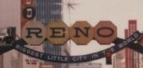 After reading news accounts about the contribution of pigeon dung to the collapse of the I-35W bridge in Minneapolis, I was reminded about how pigeons similarly factored into the destruction of the famous “RENO – The Biggest little city in the world” sign that spans the entrance to the downtown gambling district. I recall reading a the story in the 1980’s about how the old sign became inhabited by pigeons that roosted or nested in the sign. They got in through gaps in the sign and, of course, pooped while they were in there.
Image right: Reno sign, 1980’s – click to enlarge
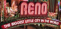 Eventually, despite having been evicted several times by the city’s maintenance crews, the pigeon problem persisted until one day there was an electrical short-circuit in the sign. The methane from the dung ignited; there was a minor explosion and a fire afterwards that damaged the sign beyond repair. The sign was removed and subsequently replaced by a newer Vegas-style beauty which electronically beckons visitors to the downtown district. While it’s a beautiful sight, the new sign doesn’t have the old sign’s charm and breaks the promise for a “little city” beyond. Recent visitors to the new Reno, if they knew the old Reno, will know what I mean.
Image left: New Reno sign – click to enlarge
As for pigeons? They’re just rats with wings.