Travel

Vacation Planner Addict

The Damsel and I have been planning a vacation. One of my co-workers recommended Google Earth® as a possible tool to help with the planning. So I tried it and now I can’t put the @!?*%$& thing aside.

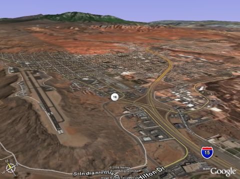
Image: screenshot of approach to St. George UT

The graphics and virtual reality are extremely intriguing to a pilot who isn’t an active flyer these days. You can get your copy from Google Earth, but you have been warned.

Maybe I can get The Damsel to post one of her pretty photos while I futz around with this.

Memorial Day Weekend

I hope everyone in the USA and all Americans enjoy the weekend and Memorial Day holiday. We started out a day early and ran some errands before commencing our weekend. One stop today found us at the flower concession in the local supermarket where I snapped this photo of the beautiful, patriotic bouquets all ready for the weekend ahead.

And please remember that if you’re planning to travel over the weekend that this weekend is statistically one of the highest-fatality weekends, so please, drive carefully!

The Alaskan Interior by Rail

Last summer, I took this shot of the Nenana River somewhere along the route from Talkeetna to Denali National Park. We boarded the train in the morning at Anchorage and rode up top of an observation car where this and other scenery was beautiful. Later, when we pulled into the McKinley Village, we checked into our hotel cabin on the banks of the Nenana where we could hear the murmur of the river all night long – well punctuated with a few loud bangs and booms since it was on the 4th of July!

The next day, we rode the train up to Fairbanks and had an overnight visit there. Alaska is interesting and certainly beautiful.

Update by Cap’n Bob: Since FIX4RSO is also a train enthusiast, I thought I would post some pix I took of the train we rode to Fairbanks — if it looks like it was pouring rain that’s because it was pouring rain:


West Beaches

There are miles and miles of scenic beaches in western Los Angeles County. During our recent excursion to the Ronald Reagan Presidential Library, we took the time to return via the shoreline. I snapped these pictures as we passed beautiful beaches and homes.

This is a shot of Zuma Beach with Point Dume in the distance.

These beach front homes are just west of Malibu – I wonder how much these guys have to pay per year for tsunami insurance? Can one even get tsunami insurance?

Avalon Bay – Then and Now

What a difference 117 years made to this serene little cove on Santa Catalina Island. This is a shot taken circa 1889 from a hill west of the bay looking toward the old Hotel Metropole. Photo credit COLA Public Library Website

And this is a shot of the bay we took last September from about the same place:

This next shot was taken from the bay looking toward the location of the old Hotel Metropole seen in the top picture (the old Metropole burned down years ago). The new Hotel Metropole hotel is located amongst the clutter just behind the tall palm trees in the center of the photo.

Damsel Sends You Catalina Island

This is a nice wide shot of the entire island of Catalina. The island is about 22 miles from end to end, and that entire span is visible in this view. This shot was made from a vantage point on the Palos Verdes Peninsula at elevation 800 feet above sea level. It was so clear that day, we could see Santa Barbara Island at a distance of 40 or so miles to the west. The view of Catalina was so clear that we could discern the famous Casino at the far east (left) end of the island with the naked eye from the mainland. You can see it as a white speck in the inset from another photo taken without a telephoto lens.