Travel

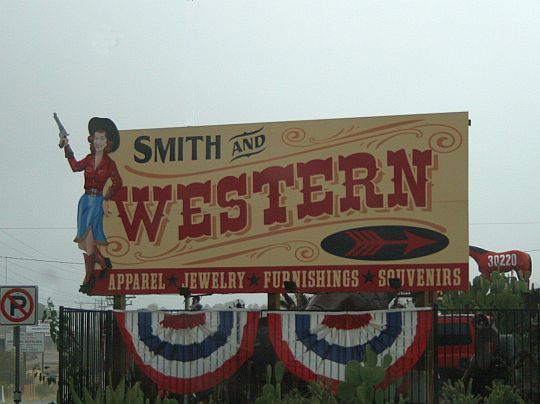
Smith and Western

We liked the town of Wickenburg, Arizona, when we were there a couple weeks ago. It seemed to have a nice out-west hometown feeling to it. We stayed at an RV park where the people that we dealt with were friendly and hospitable.

On our way out of town I snapped this shot of a billboard that captures a bit of the essence of the town. I liked the gun-friendly play on words. We were definitely not in California, anymore, Toto.

smith-western.jpg

Snowbound Clown-Mobile

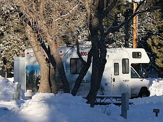
trailer-village.jpgWe rented a Cruise America® motorhome for our recent winter vacation. This was the first time we have traveled this way, as booking hotel accommodations is our usual travel mode. Since we wanted to bring our dog with us this time, we decided to try out the RV.

Shortly after we got on the road, Damsel started referring to our cruiser and others we saw on the road as the “clown-mobile.” Damsel figured the billboards painted on all sides of the vehicles made them look like part of a circus parade.

Image: Our clown-mobile in 1½ feet of snow at Trailer Village Campground – click for big

Most of the trip went well, with a couple of instances where all was not as well as it could have been. At the Grand Canyon Trailer Village Campground, we had an incident where we got stuck in the snow making the turn into the row where our campsite was located. After a bunch of digging and throwing a bunch of cinders under the duals, we were still stuck. We finally got the local AAA to pull us out, but we still needed to assist with more cinders and by engaging the motorhome drive. Once free, we got into our campsite and left the next morning without further incident.

The only other ‘incident’ was my choice of routes leaving Death Valley after our visit there – California State Route 190 from Stovepipe Wells to Olancha. It was a winding mountain road, which wouldn’t have been that much of a problem except that the setting sun was directly ahead in the general direction of travel which compromised visibility looking into the curves.

She didn’t mind getting stuck in the snow that much, but Damsel promised to file for divorce if I ever pick a road like SR190 again.
Bright Angel Canyon – Summer and Winter

Bright Angel Creek, part of the greater Grand Canyon complex, empties into the Colorado River just below Grand Canyon Village. The creek formed Bright Angel Canyon in much the same way the Colorado eroded its way through Grand Canyon. When you look down from the Village, you look straight into Bright Angel Canyon.

summer-bright-angel.jpgDuring the summer months, the sun is high in the sky at mid-day and the vivid colors of the sculptures in the canyon are truly inspirational. The sky can be gray with frequent thunderstorms in the area, or it can be blue, with flat-bottomed cumulus clouds floating above the canyon rim. The summers are warm at the South Rim with temperatures ranging between the high 70s and low 90s. When I took this shot of the canyon last summer, the temperature was in the low 80s.

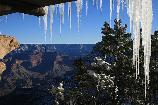
winter-bright-angel.jpgWinter brings a variety of conditions, ranging from fog and low clouds that obscure the canyon, to high winds which chill to the bone. Occasionally, a cold front will bring snowfall that can last for several days and will ice things up pretty good. The latter condition prevailed during our recent visit to the canyon. We stayed in the trailer village overnight and went to the rim to capture this winter view with low sun angle and long shadows. The snow was pretty deep in most places and the roads were pretty icy.

You can click on either image to enlarge.

The Bear Lair

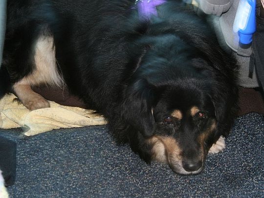
This is the very first time we have taken Bear, our 10-year old Shepard/Lab mix, on a vacation with us. At first, we worried how she would take to the motion and the ever-changing environment. Our worries were quickly dispelled when she adopted the spot between the driver and passenger seats in the cab of the motorhome. She rode there, slept there and ate there the whole trip.

bear-lair.jpg

She was especially good at taking care of business at the dog walks and seemed to enjoy exploring all the new sights, sounds and smells. We’re already planning our next trip to include our old friend and new traveling companion.

Home Again, But the Memories Linger

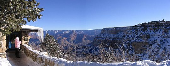
Last night, we stayed fairly close to home in the Mojave Desert, at a little town called California City. It was just another small, but nice campground, away from the ‘burbs. We went through some of the photos from this trip while we were relaxing on our last night out, and decided that we would always remember the frosty trip to the Grand Canyon as a highlight of our winter ’08 vacation.

lookout-studio-pan.jpg

Click on the image to enlarge.

Lows and Highs

20-mule.jpgWhen we got up this morning, we were in Pahrump, Nevada, near the eastern gateway to Death Valley National Park. We drove from there to Furnace Creek, near the lowest point in the continental United States. The elevation here was about 190 feet below sea level. The actual low spot is about minus 282 feet at Badwater Basin. We stopped at the village and took this picture of the wagons that were hitched to the famous 20 Mule Teams that hauled borax from here to Mojave, a considerable distance to the southwest. We then went from Furnace Creek to Scotty’s Castle, another interesting historical landmark in the park.

mt-whitney.jpgAfter we finished touring Death Valley today, we headed westward along California State Route 190, which took us over two mountain passes with winding and narrow roads. We went over the first pass and descended to Panamint Valley. Then over the White Mountains to descend into the Owens Valley, just east of the Sierra Nevada Mountains, where the highest point in the continental United States, Mount Whitney, looms at 14,491 feet above sea level. Mount Whitney in the picture to the left is not the one that looks tallest, since the linear perspective makes the peak to the left look taller. Mount Whitney is the peak among the very jagged peaks near the center and just to the right – it’s the one that looks tallest among those jagged peaks.

Click on either image to enlarge. Photo credits – Damsel.

Winter Canyon from Lookout Studio

As promised, here is one of the photos I took this morning at the Grand Canyon Village. This is looking northeast near Bright Angel Trail Head. The icicles are hanging from the famous Lookout Studio near Bright Angel Lodge.

winter-canyon.jpg

Click the image for large view.