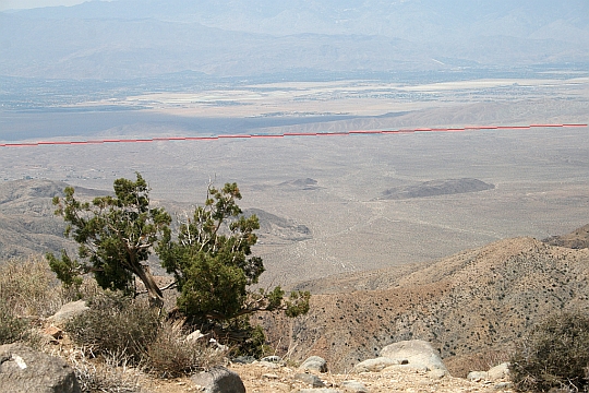
During our visit to Joshua Tree National Park yesterday, we took the short drive from the main road to a place called Keys View. From that point, you can see the Coachella Valley and the Palm Springs area five thousand feet (1525 meters) below. You can also see the San Andreas Fault (underlined in red) which has been the cause of many Earthquakes in California, including the 1906 San Francisco earthquake. Click on the image to enlarge.
In the distance behind the ridge of hills thrust up by fault motion, you can see desert communities including Palm Springs, Rancho Mirage, Cathedral City, Indian Wells, Palm Desert, Indio and La Quinta. All of these places will have a front row seat for the next major San Andreas movement in this area.
Speaking of quakes, the ground here at home is still shaking from aftershocks form the earthquake that happened in this area last Sunday. That was on the Inglewood-Newport fault, not the San Andreas. We missed the main shock since we were in Wickenburg, AZ when it hit. No damage here at home, thank goodness.


That was one hell of a Magic Marker™ that was used to outline the faultline.
Was it a US Army Corp of Engineers marker? I think it is the same marker they use to define the borders of the States so it shows up on our maps.
Actually, the Army had nothing to do with it. This is the result of a satellite-based laser illuminator which is replacing the old-fashioned USA COE mega-marker.If they crank up the power, the lines become permanent.
The technology has other uses, of course. I could tell you about them, but then . . . well, you know . . .
Nice to see the future site of San Andreas Canyon…
Canyon? Perhaps. I think maybe the future coastline of the Blue Pacific . . .
We’ll be over in Arizona when that happens.