August 2011

Valley View Panorama

valley-pan.jpg

We took a little ride today up to Yarnell, a little mountain mining town on State Route 89 north of Wickenburg. There is a steep, winding section of the road between Congress and Yarnell. On the downhill side, there is a scenic pull-out with this view of the valley south of the Weaver Mountains.

I composed this panoramic view of the valley from three exposures which I later stitched into this panoramic image. On the horizon, you can see Vulture Peak towards the left of the image; moving right, you can see the Harcuhala and Harcuvar mountain ranges toward the right of the image. In the valley below, you can see a large stockyard in the left center and the town of Congress toward the right. Click on the panorama for the full-size view.

A Moderate Shake in Virginia

intensity.jpg

According to the shake map above (click to enlarge – sorry about the crappy quality, but this is the original resolution), Washington DC is about 80 miles northeast of the epicenter of the 5.8 magnitude quake. It surprised me to hear that the quake caused officials to evacuate the Capitol and other government buildings. According to the color code, the DC area would have experienced “weak” to “light” shaking and no damage to structures.

As a former resident of a very seismically active area, I can attest that most of us who experienced that amount of shaking would simply have said “Hmmm – a little temblor.” And would go on with whatever we were doing. Some of us nerdy types would go to the USGS Earthquakes website to see the epicenter and magnitude. Maybe even look at the shake map.

Rosebud and Skylight

I got a bouquet of roses yesterday. I took one of the buds and put it in a bud vase in the little bathroom. The lighting is from a skylight that our contractor installed in the bathroom. He installed another one in the laundry, both of which take advantage of the seemingly endless sunlight to illuminate those rooms without the need for artificial light during the day. Click on the image to enlarge.

rosebud.jpg

Scenic US Hwy 60

We have a favorite place along the route between the towns of Harcuvar and Hope, AZ along US 60. It is a little mountain pass with ocotillo, saguaro and teddy bear cholla cactus. The Arizona and California railway has a track that runs through the pass and there are some Native American petroglyphs directly behind the line of sight in the panoramic image below. Click on the image to enlarge.

harcuvar-pass.jpg

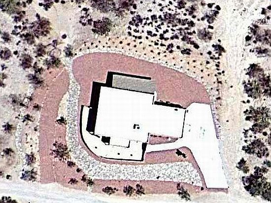
Google Aerial View Updated

goog-aerial.jpg

I was goofing around with the computer last night and discovered that Google Maps® updated their aerial photos of Wickenburg. This is our parcel with the landscaping (mostly) installed. This is the highest resolution available. North is up.

My goodness! What nice little piece of the desert!

The Hits Keep On Coming

Anyone who reads our other blog will know how heartbroken that we lost our giant saguaro cactus to root rot this morning. Add to that the 419+ point loss on the Dow today and the day is off to a rotten start.

car-battery.jpgAfter all this heartbreak and aggravation, we got all of our gear and other stuff loaded into the truck at the Arizona house to take to California only to hear stuttering clicks when trying to start the engine; the battery was almost completely dead. We like to get an early start when making the six hour trip and this would add at least another 1.5 hours to the ETA to get Triple-A out to jump us and for a short trip to the automotive shop for a new Interstate Battery.

Of course, on traversing greater California in the Los Angeles and Orange County areas, the afternoon stagnant traffic (due to the miserable infrastructure vs. population syndrome) slowed our ETA even more.

The good news is that we’re in the California house (which we deem ‘the albatross’ for now) safe and sound and we will shortly be joined by family members anxious to see us before we head back after a very short visit.